


October 10 Update · Destin Landfall · Inland Weather & Outages
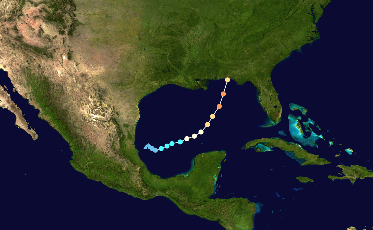
Hurricane Isaias has made landfall near Destin, Florida. The immediate questions are now where it is moving, which warnings cover your address, and how to stay safe during outages.
This update brings together official storm information, local weather and utility resources, the established super El Niño, and practical household recovery. For the wider climate and food-waste picture, visit the Climate & Sustainability Hub.
Storm data: NHC Advisory 14, . Local statement: 10:31 p.m. CDT, October 9. Later advisories supersede this snapshot. Open the current NHC advisory.

Quick Answer: Has Isaias Made Landfall, and What Happens Next?
Yes. NWS Mobile/Pensacola confirms landfall near Destin on the evening of October 9, CDT. The 03:00 UTC October 10 advisory placed the center inland, with 90 mph sustained winds and northward movement.
Keep receiving alerts, remain in safe shelter where dangerous conditions continue, and use your electricity provider's outage information. Lower wind intensity does not end the flood or surge threat. Start with local NWS updates and your county's instructions.
Where Is Hurricane Isaias Now? October 10 Storm Update
At 03:00 UTC on October 10, the NHC placed Isaias at 30.8°N, 86.5°W over the western Florida Panhandle, moving north at 20 mph. NOAA/NESDIS carries the NHC report; the 10:31 p.m. CDT NWS local statement confirms the same position and intensity.
| Measure | Reported value |
|---|---|
| Storm | Hurricane Isaias, AL092026 |
| Center | 30.8°N, 86.5°W |
| Sustained wind | 90 mph / about 145 km/h |
| Wind category at this time | Category 1 |
| Movement | North at 20 mph |
| Minimum pressure | 982 mb |
Sources: NOAA/NESDIS NHC storm description and NWS Mobile local statement, Advisory 14. The reported center and wind category describe this observation time; they are not a live location feed.
Has Hurricane Isaias Made Landfall? Where Did It Hit?
Yes. Isaias made landfall near Destin in the Florida Panhandle on the evening of Friday, October 9, local CDT. NWS Mobile/Pensacola's situation overview confirms the coastal crossing. In UTC, the storm's overnight updates fall on October 10, so check the time zone when comparing reports.
A landfall location identifies where the center crossed the coast. It does not describe the full impact area: nearby communities and inland locations can still face wind, flooding and power disruption.
Where Is Hurricane Isaias Headed Next?
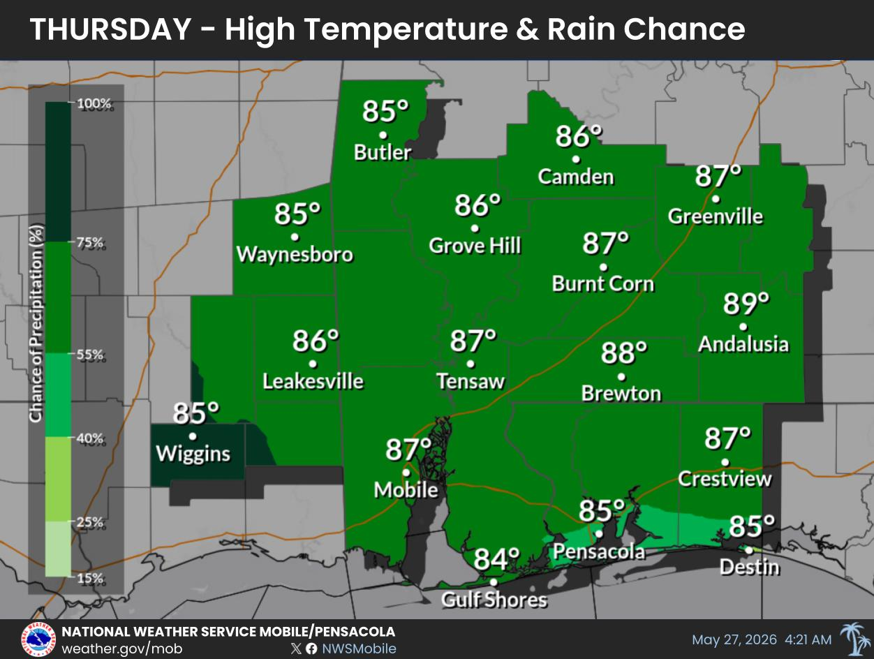
The October 10 local statement tracks Isaias north into south-central Alabama. Forecasts for Georgia and Tennessee also identify inland rain and wind risks. Use regional forecasts for your address rather than projecting the hurricane's coastal wind category over every inland community.
| Area | What the reviewed outlook says | Official updates |
|---|---|---|
| South-central Alabama | Northward storm movement, damaging winds and additional rain; the local statement forecasts another 2–4 inches, locally 6, east of the Alabama River. | NWS Mobile local statement |
| Atlanta and north/central Georgia | Long periods of strong gusts, heavy rain and flooding risk. Rainbands can produce tornadoes; check individual warnings and their valid times. | NWS Atlanta/Peachtree City |
| Nashville and Middle Tennessee | Remnant-system outlook: 1–3 inches of rain and gusts up to 45 mph over the weekend, with the heaviest rain on Saturday and Saturday night. | NWS Nashville |
Use the Official Hurricane Tracker With Local Warnings
The NHC hurricane tracker provides the official track and intensity forecast. The cone represents uncertainty in the center's path; hazards extend outside it. “Spaghetti models” show individual model guidance and should not replace the official forecast for household decisions. Read the NWS forecast-product guide.
Destin, Pensacola and Panama City Beach: What Should Residents Check?
Check the local forecast, active alerts and county instructions separately. The Mobile local statement keeps damaging wind, coastal surge and rainfall flooding in focus. Its immediate tornado assessment is lower for that office's area, while the Georgia outlook still identifies a rainband tornado risk. These are different forecast areas.
| Location | Weather information | Local instructions |
|---|---|---|
| Destin / Fort Walton Beach | NWS Mobile/Pensacola | Okaloosa emergency management |
| Pensacola / Escambia County | NWS Mobile/Pensacola | Escambia emergency information |
| Panama City Beach / Bay County | NWS Tallahassee | Bay County evacuation-zone information |
A zone map identifies exposure; current local orders determine what to do. Do not assume that a lower wind category, a nearby cleared alert, or being outside the track cone makes your road or home safe.
High Wind Warning, Extreme Wind Warning and Tornado Watch: What Is the Difference?
Read the alert's name, location and expiration time. These products call for different actions; a watch is not a warning.
| Alert | Meaning | Action |
|---|---|---|
| High Wind Watch | Strong winds are possible. | Prepare and adjust plans before unsafe conditions arrive. |
| High Wind Warning | Dangerous strong winds are occurring or imminent under local criteria. | Take shelter; follow the alert's instructions. |
| Extreme Wind Warning | Major-hurricane sustained winds of 115 mph or more are expected within an hour, usually near the eyewall. | Immediately shelter in the interior of a well-built structure. |
| Tornado Watch | Tornadoes are possible across the watch area. | Keep alerts on and be ready to reach shelter quickly. |
| Tornado Warning | A tornado is observed or indicated by radar. | Move immediately to a small interior room on the lowest floor of a sturdy building, away from windows. |
Definitions: NWS wind alerts, NWS hurricane and extreme-wind products, and NWS tornado alerts. This table explains alert types; it does not assert that every listed alert is active at your address.
Alabama Power Outages and FPL: Where Can You Check Restoration?
Use the electricity provider named on your bill. A statewide outage headline does not tell you when your own service will return.
Alabama Power links its outage map and reporting tools from the storm center. FPL lets customers search by address, city or ZIP code; its Power Tracker guidance explains that information can be limited during major-storm assessment. Restoration times are estimates that may change.
Keep clear of downed lines and report them to the utility. Treat food safety and safe shelter as immediate priorities while crews work.
If your GEME loses power, stop adding fresh scraps. Keep new scraps in a separate covered container. Resume only after safe power restoration, normal operation and the microbial bed have been checked. Follow the GEME power-outage guide; flood-exposed equipment needs professional assessment before reuse.
How to Stay Safe During Isaias and Begin Recovery
While Dangerous Conditions Continue
- Keep receiving warnings. Use a charged phone, battery radio or NOAA Weather Radio and alerts that can wake you at night.
- Follow local shelter and evacuation instructions. Avoid making a new trip through dangerous wind or flooded roads.
- Stay away from floodwater and fallen power lines. Wait for official clearance before returning to damaged areas.
- Use fuel-burning generators outdoors. Keep them at least 20 feet from windows, doors and vents, and use a battery-backed carbon-monoxide detector.
Guidance: NWS hurricane planning and CDC hurricane recovery precautions.
Protect Refrigerated and Frozen Food During an Outage
Keep refrigerator and freezer doors closed. FoodSafety.gov gives about 4 hours for an unopened refrigerator, 48 hours for a full freezer and 24 hours for a half-full freezer. Check its food-specific temperature rules before deciding what is safe. Never taste food to test safety, and discard food exposed to floodwater.
Restart the Kitchen Routine After Safety Checks
Check utilities, food and equipment before cleanup or restarting appliances. Floodwater-contaminated material needs an appropriate disposal route; keep it out of the GEME chamber. Continue with the hurricane recovery guide once immediate hazards have passed.
Climate Background: Super El Niño Is Already Established
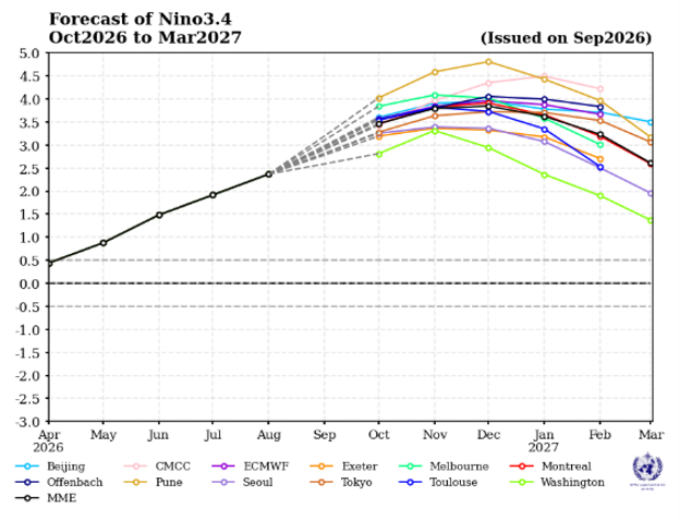
A very strong, or “super,” El Niño is already established in 2026. Further intensification and the eventual peak remain forecast questions.
The WMO October 8 update confirms an established, rapidly strengthening event, reporting an August monthly Niño-3.4 anomaly of +2.5°C. The Met Office September 23 assessment describes the event's present strength as unprecedented.
The event is already here; seasonal forecasts describe what happens next. “Super El Niño” is a widely used description of exceptional strength, rather than a separate official ENSO phase. NOAA uses strength categories such as strong and very strong.
| Evidence | Period | What it tells us |
|---|---|---|
| WMO observed Niño-3.4 warming | August 2026 monthly mean | +2.5°C: a substantial warm anomaly is already present. |
| Met Office current assessment | Published September 23, 2026 | Present event strength described as unprecedented. |
| NOAA CPC seasonal outlook | October–December 2026 | 83% chance of meeting its stated historic-strength, three-month RONI criterion. |
NOAA's October 8 outlook gives more than an 83% chance of strong-to-very-strong conditions through January–March 2027. Its historic-strength forecast uses a three-month Relative Oceanic Niño Index (RONI) of at least +2.5°C, with an 83% chance for October–December. Read the NOAA ENSO discussion for the index and period.
Match the measurement before comparing numbers. Monthly Niño-3.4 anomalies, relative sea-surface temperature maps and three-month RONI forecasts use different methods or reference periods. None is a direct measurement of global air-temperature rise.
Why Can an Atlantic Hurricane Form During El Niño?
El Niño tends to increase Atlantic vertical wind shear, making the environment less favorable for hurricanes. This reduces seasonal odds but does not eliminate storms. A particular hurricane's development still depends on its local ocean and atmospheric conditions. See NOAA AOML on El Niño and Atlantic hurricanes.
For the full seasonal discussion, continue to the GEME El Niño 2026 forecast and U.S.–Europe guide.
What Could a Very Strong El Niño Mean for the U.S. and Europe?
El Niño changes the likelihood of regional seasonal patterns. It does not specify the weather at every address or on every day.
| Region | Possible pattern | Useful preparation |
|---|---|---|
| Southern United States | Typical El Niño winters favor wetter, often cooler conditions and a more active southern storm track. | Review flood exposure, drainage and winter alerts. |
| Northern United States | Warmer and drier winter tendencies in many northern areas; local exceptions remain. | Use regional outlooks; retain cold-weather preparation. |
| Northwestern Europe and the UK | The Met Office's 2026 discussion raised the chance of wetter, stormier autumn and early-winter conditions. | Maintain rain protection, drainage and outage plans. |
| Other European regions | The northwestern-Europe outlook is not a continent-wide forecast. | Use national meteorological-service forecasts for local planning. |
U.S. tendencies: NOAA El Niño overview. Northwestern-Europe outlook: Met Office 2026 assessment.
The Met Office's September 23 discussion also raises the chance of a milder, wetter and stormier early winter in the UK, with increased potential for cold weather later as the polar vortex can weaken. Other drivers influence the result. Use its current winter-context assessment alongside seasonal climate-driver guidance.

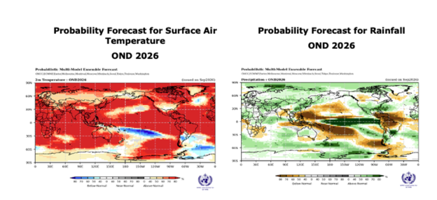
Use the global map to compare broad seasonal signals, then consult your national weather service for local decisions. Its October–December period differs from the typical whole-winter diagram above.
How Are Extreme Weather and Environmental Protection Connected?
Long-term warming can amplify hurricane hazards, while the cause and intensity of an individual storm require specific analysis. NOAA/GFDL research connects warming with higher tropical-cyclone rainfall rates, increased average intensity and a larger proportion of very intense storms. Rising sea levels can worsen coastal inundation when storms occur. The total number of storms need not rise alongside those hazards.
That evidence does not by itself establish how much human-caused warming changed Isaias. Read the NOAA/GFDL hurricane and climate research overview for the scientific distinctions.
Two household tasks follow: adapt through alerts, evacuation planning and safer homes; mitigate by reducing recurring emissions. Compost-enriched soil can improve water retention and reduce erosion, according to EPA composting guidance. Soil care belongs in long-term resilience planning; evacuation decisions still depend on official hazards.
Explore that practical connection in the food waste, soil and climate-resilience guide.
How Can Individuals Reduce Greenhouse Gas Emissions Every Day?
Start with repeatable changes in transport, home energy, food and purchases. Choose actions that fit your household and track whether they last.
| Daily area | A practical action | Why it helps |
|---|---|---|
| Travel | Replace suitable car trips with walking, cycling or public transport; combine necessary trips. | Reduces transport energy demand. |
| Home energy | Improve insulation and use efficient heating, cooling and appliances. Consider cleaner electricity options. | Reduces energy use and fossil-fuel dependence. |
| Meals | Include more plant-based meals that meet household needs. | Can lower food-system emissions. |
| Purchases | Maintain, repair and reuse durable goods before replacing them. | Limits demand for new materials and production. |
| Food storage | Plan portions, rotate ingredients and use leftovers safely. | Avoids wasting food and its upstream resources. |
| Unavoidable scraps | Use a suitable organic-recovery route and apply its output correctly. | Recovers useful material and can divert scraps from landfill. |
Demand-side climate actions: IPCC AR6, Working Group III, Chapter 5. Food practices: EPA household food-waste prevention.
Prevent Food Waste Before Processing Scraps
Keep a visible “use first” area, shop from a list, and refrigerate or freeze food safely. Buy the quantities you expect to eat. The GEME food-waste reduction guide turns these habits into a kitchen routine.
EPA ranks prevention as the most environmentally beneficial food-waste action. Landfilled food can generate methane as it decomposes without adequate oxygen. For suitable unavoidable scraps, consider local organics collection, community composting or an appropriate home system. Compare the pathways in the EPA Wasted Food Scale.
Use bills, travel logs and a short food-waste record to identify changes you can sustain. A claimed household emissions saving needs defined boundaries and evidence; one recycling habit cannot account for the whole footprint.
After Recovery: GEME Makes Daily Food-Scrap Processing Easier Indoors
For a household that wants to process suitable kitchen scraps indoors every day, GEME Terra 2 and GEME Pro offer a clear practical advantage: continuous microbial processing without depending on daily access to an outdoor compost pile. Once safe power and normal conditions return, smaller additions can follow meal preparation and cleanup while the active microbial bed continues working.
GEME uses an active microbial bed and automated mixing. It produces Compost Base for further handling and soil blending, rather than relying on grinding and drying alone. Its permanent odor-control system avoids scheduled replacement odor filters. Read how GEME works and the microbial composting and dehydrated-scraps guide.
| Model | Chamber | Daily capacity | Choose by routine |
|---|---|---|---|
| GEME Terra 2 | 14 L | Up to 2 kg/day | Lighter kitchen loads, commonly 1–3 people |
| GEME Pro | 19 L | Up to 5 kg/day | Heavier cooking and larger households, commonly 4+ people |
Measure suitable daily scraps before choosing a model. Keep each addition within 1 kg and follow the model's feeding instructions. Daily throughput is not a single-addition allowance.
For plant use, screen harvested material and return suitable unfinished pieces to the chamber. Blend about 1 part Compost Base with 8 parts plain soil, then follow the soil-capping and planting instructions in the GEME application guide.

Plan the complete recovery route: prevent edible food waste, account for electricity, and use the Compost Base according to the soil instructions. Compare ongoing use in the GEME electricity-use and ownership guide.
Build a Better Everyday Food-Scrap Routine
Prevent edible food waste, then give suitable scraps a continuous microbial route. Choose Terra 2 for lighter daily loads or Pro for heavier family cooking.
Frequently Asked Questions
Where is Hurricane Isaias now?
At 03:00 UTC on October 10, 2026, the NHC reported the center at 30.8°N, 86.5°W, moving north at 20 mph. This is a dated position; check the latest advisory for its present location.
Has Hurricane Isaias made landfall?
Yes. NWS Mobile/Pensacola confirms that Isaias made landfall near Destin, Florida, on the evening of October 9, 2026, local CDT. Landfall does not end inland wind or water hazards.
What category is Hurricane Isaias in the October 10 update?
The 03:00 UTC October 10 update reported maximum sustained winds of 90 mph, within Category 1. That category describes wind intensity at that time; flood and storm-surge threats require separate checks.
Where is Hurricane Isaias headed after landfall?
The reviewed Mobile local statement tracks the storm north into south-central Alabama. Georgia and Tennessee forecasts also identify inland rain and wind risks. Use current regional forecasts for later track and intensity changes.
What does a high wind warning mean?
A high wind warning calls for action when dangerous strong winds meet local warning criteria. Seek safe shelter and read the alert location, timing and instructions. A high wind watch means those conditions are possible.
What is an extreme wind warning?
An extreme wind warning covers major-hurricane sustained winds of at least 115 mph expected within an hour, usually near the eyewall. Shelter immediately in the interior of a well-built structure when the warning applies to you.
Is a tornado watch the same as a tornado warning?
No. A watch means tornadoes are possible. A warning means a tornado is observed or indicated by radar and calls for immediate shelter in an interior room on the lowest floor of a sturdy building, away from windows.
Which forecasts cover Destin, Pensacola and Panama City Beach?
Use NWS Mobile/Pensacola for Destin and Pensacola, and NWS Tallahassee for the Panama City Beach area. Check your exact address and county emergency instructions because conditions and orders vary locally.
Could Isaias affect Atlanta or Nashville?
The reviewed Georgia outlook identifies strong winds, flooding rain and possible rainband tornadoes. Middle Tennessee forecasts identify remnant-system rain and gusty winds over the weekend. Follow NWS Atlanta/Peachtree City or NWS Nashville for local updates.
Where can I check Alabama Power or FPL outages?
Alabama Power customers can use its Outages and Storm Center and outage map. FPL customers can use Power Tracker. Check your own provider, refresh its information, and treat restoration times as estimates.
How long can refrigerated food stay safe during a power outage?
With doors closed, FoodSafety.gov gives about 4 hours for a refrigerator, 48 hours for a full freezer and 24 hours for a half-full freezer. Use its food-specific temperature guidance; never taste food to test safety.
Has a super El Niño already formed in 2026?
Yes. WMO confirms an established, rapidly strengthening El Niño, and the Met Office describes exceptional present strength. Forecasts of a later peak or record seasonal index remain predictions; use the stated index and period when comparing them.
Can El Niño suppress Atlantic hurricanes and still allow Isaias?
Yes. El Niño can increase Atlantic wind shear and reduce seasonal hurricane activity, but it does not prevent every storm. Individual development still depends on local ocean and atmospheric conditions.
Can GEME keep processing normally during a power outage?
GEME is electrically powered. Stop adding fresh scraps during an outage and keep new scraps separate. Check safe power restoration, normal operation and the microbial bed before resuming. Flood-exposed equipment needs professional assessment before reuse.
How does GEME help with food scraps after normal conditions return?
Terra 2 and Pro support continuous indoor microbial processing with automated mixing and no scheduled odor-filter replacement. Terra 2 handles up to 2 kg/day and Pro up to 5 kg/day; keep each addition within 1 kg and follow the model instructions.
Does composting automatically make a household carbon neutral?
No. Prevent edible food waste first. The outcome of processing unavoidable scraps depends on the disposal route replaced, equipment, electricity and how the output is used. Follow the Compost Base screening and soil-blending instructions.
Sources and Related Guides
Storm snapshot: NHC Advisory 14, October 10, 2026, 03:00 UTC. Regional statement: 10:31 p.m. CDT October 9. ENSO assessment: October 8. Live NWS graphics and utility pages can update independently; read their displayed timestamps and current local instructions.
- NOAA/NESDIS: Isaias satellite imagery and NHC storm descriptions
- NOAA National Hurricane Center: active advisories and forecast graphics
- NWS Mobile/Pensacola: landfall confirmation and regional hazards
- NWS: hurricane watches, warnings and the forecast cone
- NWS: hurricane preparation checklist
- CDC: safety during recovery, floodwater and generator precautions
- FoodSafety.gov: food safety in a disaster or emergency
- WMO: established El Niño, observed warming and the October–December outlook, October 8, 2026
- Met Office: present El Niño strength and the winter outlook, September 23, 2026
- NOAA CPC: ENSO Diagnostic Discussion, October 8, 2026
- NOAA: understanding El Niño and its regional effects
- NOAA AOML: El Niño and Atlantic hurricane activity
- Met Office: the developing 2026 El Niño and the weather outlook
- Met Office: ENSO and other seasonal climate drivers
- NOAA/GFDL: research on global warming and hurricanes
- IPCC AR6 Working Group III: demand, services and mitigation
- EPA: preventing wasted food at home
- EPA: Wasted Food Scale and landfill methane
- EPA: composting at home and soil benefits
- NWS Mobile: Hurricane Isaias local statement, Advisory 14
- NWS Atlanta/Peachtree City: Georgia inland outlook
- NWS Nashville: Middle Tennessee rain and wind outlook
- NWS Tallahassee: eastern Panhandle forecasts
- NWS: high wind warnings, watches and advisories
- NWS: tornado watch and warning definitions
- Alabama Power: storm, outage and reporting tools
- FPL: Power Tracker and major-storm information



Dejar un comentario
Todos los comentarios se revisan antes de su publicación.
Este sitio está protegido por hCaptcha y se aplican la Política de privacidad de hCaptcha y los Términos del servicio.